Oh Man do we have a series of fabulous blogs originally posted
on GoSmokies between April 30 and May 4, 2014
What me Obsessed?
OK now that all the
good pictures and great blogs have been shared about this past Sunday’s
GoSmokies hikes, let me chime in with my dull and boring pictures and dialogue
about the day’s event.
It takes me a little
longer to post stuff because…well…let’s just say I am not a NORMAL
hiker. Depending on the particulars of the hike there may be hours of planning
and even more hours of work after a hike. Like Mike Maples, I am a map junkie.
In fact, take the “le” out of Maples and what have you got. Now wait a minute
my fellow GoSmokians, are y’all thinking we are obsessed? Well, to give you an
idea and let you make up your mind on this, let’s take a look at the typical
“process.” I am sure Mike Maples has his own process. And maybe there are a few
other closet junkies out therewith their own process.
Since, much of my
hiking is off trail, I have found (from hard life lessons) to KNOW where I am
going first. I like to know what creeks, ridges and other useful information
about the area I plan to enter. And while it is fun to find the unexpected, I
like to have some idea of what I am looking for. Nothing is more frustrating
than looking at a map later only to find you just missed a home place. It is
especially bad when said home place is several miles into the hike.
Now it is time to
plot some waypoints to at least get me in the vicinity of what I am looking
for. If you have gone looking for a home place you plotted on a GPS, you
already know this is not always as easy as it sounds. An area that looks open
on a map may be filled with our favorite shrub – rhododendron. Creeks are not
always as easy to follow as they may appear on a map either.
So now we have done
our homework and have maps and waypoints on a GPS. Let’s go hiking!
And don’t forget to
bring the Maples!
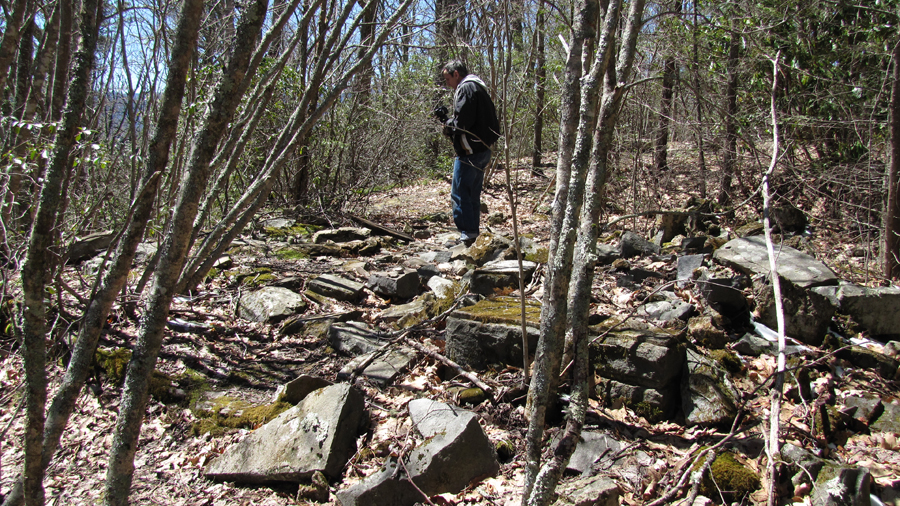
Last Sunday, I had
Mike take me on some short hikes while the rest of youse was getting ready for
the big event. First, we went to the Mark
Ogle Cemetery
mentioned in Pete Prince’s research. Above you see Maples caught in the act of
dowsing. Later, we took the rest of the gang to visit the cemetery. Both,
myself and Maples have done some homework on this one and it is possible that
there are five graves here. However, it’s nothing that could be proven without
digging them up – which of course we have no intention of doing.
So, we have done our
hike and now the real work comes in. Hundreds of pictures downloaded onto my
computer. First round through, I delete some of poor quality photographs. At
this point, most folk are done. But not for the obsessed! Not only do I want a
file with pictures of the day’s events… I now make files for home places,
waterfalls, cemeteries and anything else I can think of. GPS waypoints will be
assigned numbers as will the files to correlate with them. And don’t forget a
file for the blog!
Depending on how much
I knew going into the hike, I may have to research to find names for some or
all of the home places found. So making that map y’all enjoy so much could take
a half hour or might take a couple hours. Here is the overall map of last Sunday’s
hikes.

Now to create files,
go through the pictures and get stuff organized. After going through Pete
Prince’s files, I decided that I needed to add “Field Notes” to my files. Some
of the Prince files indicated his sources while others provided little
information; which left me wondering where he got his cemetery information
from. How did he get the name and who (if anyone) told him about them. The
Smokies are far too vast to be wandering around dowsing at random. I know that
I have a lot of files that will leave people wondering where I got the name
from. Hopefully, I will get to all of them in the future. For now, I include a
word doc with my sources and any other information in the file. I also include
my maps and any other maps for further documentation. If I have any historical
photos, a file is inserted with those too. Whew, anyone need a break?
Sometimes it is fun,
but there are those tedious moments that make you wonder why you do it. I
appreciate that someone talked Pete Prince’s heirs into donating his work to
the UT Library. Pete died before he could get any of his work published. Had
his files not been donated to the library then his work would have been lost
forever. To get his work though, you will have to spend hours scanning
documents. Mine is all on a computer and can therefore be downloaded. Anyone
want to venture a guess at how many Gigs you will need to download everything?
So here I sit
mid-week and I am still going through pictures and making files. However, what
a great day it was spending time with my GoSmokies family.
It was a little
different in that the second hike was not much longer than the first. My GPS
logged the first hike at 2.7 miles and 3.0 for the second. Keep in mind that I
tend to wander around a bit so my mileage was probably a little longer. Still,
there was not a lot of difference in length between the two hikes.
Once I get all of my
stuff together I will post a couple more blogs and probably a photo album of
pictures. It has been slow this week as I have also been recovering from my
Penguin attack by Richard Owens highly trained Ninja Penguin squad.
GoSmokies Hike One: Curtis Shakes a Leg
We dedicate to the
first GoSmokies hike to our good brother Curtis Travis. You may have already
seen the cute pictures of his wife putting her hand on Curtis’ back. Awwwwww!
They really are a cute couple! Curtis has had some health issues this past year
and he has bounced back with a vengeance. I have watched him struggle and I
have seen him call it “good” for the day. But he gets out there and gives it
his best. I respect a man who gives it his best and I respect him when he knows
his limits and says he’s has had enough. Sorry that we did not find you any 30
foot chimneys today Curtis, but it was and always is a great day in the
Smokies. Love ya man, and proud to consider you a brother.
OK, enough mushy
stuff…
Curtis I know you
want to know where we went so here’s the map for hike one:
And I know that you
want to know what all those numbers mean so here is a list which includes
everything for the day:
And Curtis, just in
case you ever need a hug be rest assured that you’re other Mike brother with
the last name of Maples is there for you.
We left the Twin
Creeks Pavilion for a short hike to the first home of Louis E Voorheis
according to Mike Maples Map. Voorheis owned a nice piece of land and later
built a home which became known as a mansion and is still in use today by the
Park Service.
After checking out
one of the many Mill remains and the Voorheis
Mansion we went up the
road to find home places along the Twin Creeks trail. There are several that we
visited but many more that folks could visit on a longer hike.
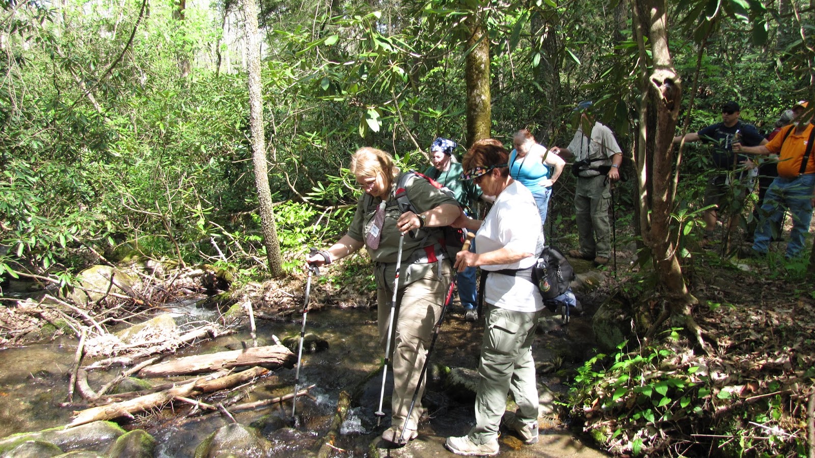
The highlight of the
hike was a lesson in stream crossing with Master Stream Crosser Richard Owen.
Duane Pierce follows Richard awestruck by his masterful strides.
We did take everyone
to the Mark Ogle Cemetery
which I mentioned in the first blog. I handed my rods to Mike Maples for a
demonstration in the art of dowsing. Mike did a blog about this site that you
can reference.
Mark Ogle lived
nearby and the Bud Ogle Place
is just up the trail from his residence. Ogle’s dominated this area however;
you can find some other mountain families such as Huskey and Ramsey in the
area.
Others have pointed
out the wildflowers that stopped hikers dead in their tracks. We decided that
we better turn back for lunch – especially if we wanted to do a second hike. I
believe the head count was 23 for the first hike. I think we came back with 22
or maybe it was 24. We did pass a few other hikers who were stopped and
interrogated by Mike Maples. I think he was telling one young lady about the
Moose that were released up the road in Cherokee Orchard. I was going to tell
her about my Penguin sightings but she had already started running up the
trail. Whether she was running to see the Moose or to get away from Maples we
will never know! Either way it was time to return for some good ol’ GoSmokies
fellowship and good eats.
GoSmokies Halftime - Louis E Voorheis Grave
It’s Halftime at the
GoSmokies Spring Event. Time to rest, socialize and most importantly – EAT!
You have probably
seen some pictures of the healthy food we enjoyed. I myself held back and only
had three pieces of cake! Along with Lays potato chips and a half of peanut
butter pita sandwich, I was fueled up and ready to go.
While the others
enjoyed lunch, I grabbed Mike Maples for a short walk back over to the Voorheis Mansion.
I wanted to see if we
could locate the grave of Louis Voorheis which was supposed to be next to a
large rock behind the house. There is a nice picnic area complete with table
and fire pit behind the house.
Next to the picnic
table is a large rock where we believe he was buried.
Rather than tell you
where we got our information from, I will just show you the document from an
email Pete Prince sent to a friend.
We are pretty sure we
found the spot behind the rock where the remains were buried. Both of us dowsed
around the rock and did get a crossing of the rods in one particular spot. It
appeared to be where Prince had it marked on his map. There were other rocks
and the map was pretty crude so we are not 100% we got the exact spot but it is
known that his remains were buried in this area.
OK, are we all rested
up and ready for another hike?
GoSmokies Hike Two - And then there were Eight
After a rest and some
socializing, Mike Maples instructed us that it was time for hike number two.
Some folks decided they had enough of the Mike’s for one day and opted for
calmer adventures. Marlene came along only because she had not made enough
stream crossings for the day. A hike without a dozen stream crossings for
Marlene is like a hike without rhododendron ugly for Maples. Jack Lail was
abducted for hike number two by the wiley Maples who said that Jack was going
to be a Mountain Jedi whether he wanted to be or not. But before we could
embark on our journey, Maples told us about the trout he caught one summer day
in the cold icy waters of LeConte Creek.
Maples never
exaggerates – lol.
As previously stated,
the hike was not much longer than the first days hike.
We left out from the Bud Ogle Place and
stopped just off the road at the Robert Ogle place (1311). Very little left of
the chimney but a nice springhouse remains are nearby. You can see an old rock
wall lined road behind the place heading over to the other side of Cherokee
Orchard road.
Next we visited the
Birdwell Huskey place (1148) where a large chimney fall indicates that this was
once a large house. There is a picture of this chimney in my picture album.
In case you are
wondering why the GPS numbers jump all over, it is because I have found some of
these places on earlier hikes.
We crossed LeConte
Creek at a small waterfall and headed up toward the Old Sugarlands trail. Just
before reaching the trail we came to Oscar Ogles Place (1313).
We came out on the
road and followed along it until we reach the old barn foundation near Rocky
Steve Huskey’s place (1314).
We found lots of
stuff in the area as we continued along over to the Bill Ramsey Place (1315).
All that remains at
the Ramsey place is a large indentation where a barn or cellar was. There are
several boxwoods in the area as you continue downhill toward Rev. Sam Oakley’s
land (1316). You come to several rock was remains and I believe I found the
chimney remains near the creek with another rock wall behind where the house
once stood. At this point the group was heading left back toward the road so I
rejoined them as we hit the road.
We returned with all
8 brave souls, although Marlene observed that we had never reached the 12
stream crossing minimum. Oh well, maybe another day.
GoSmokies - After the Ordeal
The GoSmokies Events
are always fun and it is great to see old friends and meet new ones. I had
started the day out with Mike Maples scoping out some home sites and a
cemetery. During our second hike, Mike had mentioned a springhouse remains
about a quarter mile off the road that he wanted to take me too. So we headed
back up Cherokee Orchard road and parked near the Huskey Barn remains. We
headed of trail near a wet branch and came out on Trillium Gap trail between Rainbow Falls
and Grotto Falls parking areas.

We talked about the
1931 map and how we both had looked for a home site above the trail. We both
had found rock walls and several flat spots that would be good for a home
place, but neither of us had ever found the home place. Mike was looking for
where we needed to head down to the springhouse remains when I stopped him. I
spotted a metal box off the trail. As I went over to get pictures of it, Mike
went on above the box. We both were finding stuff as we walked and in a moment
Mike yelled out that he found the chimney remains.
Not much left of the
chimney but there was some foundation remaining in front of it. A moment later
I saw Mike stooping over to take a picture of something else he had found.
Turned out to be part
of a Westinghouse Washer. On Mike’s map he shows this as Robert Ogle’s place,
however, he said that it was a different Robert Ogle than the one we had
visited earlier.
We started over to a
creek where Mike thought the springhouse was. Finding no remains we headed back
across below the Ogle place. Just below it we found the Springhouse remains.
It was a short hike
that exceeded both our expectations. We found the home place we had looked for
below the trail instead of below it, but both of us commented that the old road
on the 1931 map may not have been today’s trail. Could be that this was a
different home site, but no matter we had found it and headed back to the car
more than satisfied.

The day had come to a
close and now it was time for the after hike obsession to kick in and sort
through the many pictures of places we had visited. For those who have never
made it to a GoSmokies event do not fear for I am sure there will be more to
come. The pace is much slower due to the numbers of people, which is great for
those who are not accustomed to off trail hiking. We generally do not pick
strenuous hikes so they are great for folks new to this sort of thing. And
those who have attended will tell you that we have fun. There is a lot of
joking around and great stories. You can count on Professor Maples for some
good history lessons and of course you can watch me zig zagging around looking
for anything I can find. What really makes this special is the knowledge shared
by others. There really are no stars and I have had several people share things
with me on these hikes. For some folks it is just great to put faces with the
names. For those who attended you have my sincere thanks and I appreciate the
kind words for the blogs and am grateful for your friendship. For those who
have not made it, I hope to see you at a future GoSmokies event. As always, I
give a big hug and lots of love to Eleanor and Bonnie who do a lot of the
behind the scenes work in making these events happen. Me and Maples get a lot
of the glory for doing the hikes but it is these two lovely people who really
make it happen.
GOSMOKIES PICTURES